SkyDemon is one of Europe's most popular solutions for VFR flight planning and in-flight navigation.
Use this app to access your SkyDemon subscription on your Android device, unlocking SkyDemon's powerful features while on the move.
FLIGHT PLANNING FEATURES
- SkyDemon vector charts are the clearest aeronautical charts you'll ever use, with dynamic airspace clipping and choice of map layers
- Route planning is as simple as touching consecutive waypoints and dragging to make changes
- Virtual Radar shows how your route relates to airspace, terrain, obstructions and other features
- Pilot Log facility calculates headings and groundspeeds from actual wind data, and shows useful frequencies
- Plates and other documents for relevant airfields are displayed automatically as you plan, and many are available georeferenced for use in flight
- Intuitive pan, pinch and rotate support with no loss of map clarity or text legibility
- File a VFR flightplan for your route directly to air traffic controllers
- Automatic TAF, METAR and SIGMET briefing as you plan a route, with graphical decoding
- Rainfall data can be overlaid on the main map, with animation, showing the trend of rainfall over time
- Integration of GAFOR route forecasts for Switzerland, Austria, Slovenia and Croatia
- Both narrow-route and area NOTAM briefings available, updated as you plan
- Advanced NOTAM graphical interpretation and depiction on the main map
- Easily print your PLOG and the output from various briefings
- Warnings for airspace and other potential hazards to your flight, updated in real time
- Airfield Admin Information shows useful contacts and other details for airfields featured in our charts
- Forecast winds aloft are automatically retrieved for the flight time and displayed on the map
- Create an advanced flight performance profile for each aircraft you use
- ATS Routes mode offers an alternative chart presentation for flight along airways
- Accurate fuel, weight and balance calculations including flight costings
- Create an unlimited number of user-defined waypoints
- Analyse your track logs for posterity
- Choose between six different vector chart styles
- Extensive European chart coverage as standard
GPS NAVIGATION FEATURES
- Intelligent warnings for approaching airspace, NOTAM, obstacles, terrain and other hazards
- Virtual Radar shows a side-on projection of all approaching features and how your trajectory relates to them
- Vector map automatically follows the aircraft in north up, track up or course up orientation
- Clear and concise instruments show you flight statistics and help keep you on track
- An HSI/ILS instrument helps you keep to your planned route and line up early for approach
- Live Pilot Log shows progress through your route, ETAs, ATAs and useful frequencies based on your current position
- TerrainSafe dynamically colours mountainous terrain around you to quickly identify safer areas
- Direct To allows easy re-routing in a hurry by picking from a selection of nearby airfields
- Approach Information shows runway diagrams, TAF, METAR, NOTAM and other airfield details useful for making an approach
- Live updates of TAF and METAR while in flight, with associated alerts*
- Extended runway centrelines appear automatically on the map as you near your destination airfield
- Permanent display of position relative to nearest well-known waypoint, for position reporting
- Easy changing of the planned route while in flight by touching and dragging
* Internet connection required for live weather update while in flight
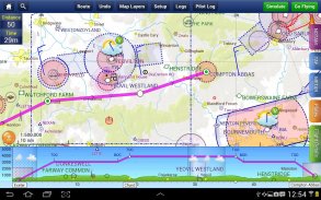
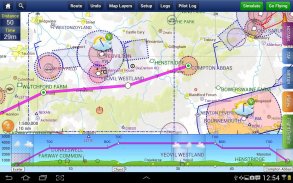
SkyDemon是欧洲最流行的目视飞行计划和飞行导航解决方案之一。
使用这个应用程序来访问你的Android设备上的SkyDemon订阅,解锁SkyDemon的强大功能,同时在移动。
飞行计划功能
- SkyDemon矢量图形是你永远使用清晰的航图,地图图层动态空域剪裁和选择
- 路线规划是连续触及航点并拖动进行更改那么简单
- 虚拟雷达显示路线如何与空域,地形,障碍物和其他功能
- 先导日志工具计算标题和groundspeeds实际风数据,并显示出有用的频率
- 在规划相关的机场板及其他文件会自动显示,许多可用于地理参考在飞行中使用
- 直观的锅,捏和,没有清晰的地图或文本清晰度损失旋转支持
- 直接提交一份飞行计划目视为你的路线,空中交通管制
- 自动TAF,METAR和SIGMET简报作为你规划路线,以图形解码
- 降雨的数据可以在主地图上重叠,以动画,表示降雨量随时间的趋势
- 的GAFOR路线预测瑞士,奥地利,斯洛文尼亚和克罗地亚整合
- 提供两个窄路线和区域NOTAM简报,更新计划
- 先进的图形化NOTAM解释和描绘主地图上
- 轻松打印PLOG和各种简报输出
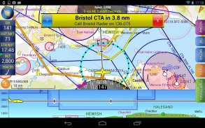
- 警告空域和其他潜在危害您的航班,实时更新
- 机场管理信息显示了我们的图表功能机场有益的接触和其他细节
- 预测高空风的飞行时间自动检索和显示在地图上
- 创建为你使用每架飞机的先进的飞行性能配置
- ATS路由模式提供了一种替代海图显示沿航空公司的航班
- 精确的燃料,重量和平衡计算,包括飞行成本计算
- 创建用户自定义航点的数量不受限制
- 分析为后人您跟踪日志
- 六种不同的矢量图风格之间选择
- 广泛的欧洲图表覆盖率标准
GPS导航功能
- 对于接近领空,航行通告,障碍物,地形和其他危害智能警告
- 虚拟雷达显示的所有功能接近一个侧面上投影和你的轨迹如何与他们
- 矢量地图自动跟随北下上了飞机,跟踪或病程最长方向
- 简单明了的仪表显示你的航班统计和帮助你保持正轨
- 一个HSI / ILS仪表可以帮助你保持你的计划路线和早排队进场
- 现场飞行员日志显示通过你的路线,有了ETA,ATAS和有用的频率进步根据您当前的位置
- TerrainSafe动态色彩山区周围您快速识别安全地区
- 直接到可以轻松重路由急于通过从附近的选择飞机场采摘
- 手法信息显示跑道图,TAF,METAR,航行通告等机场的详细信息用于制作方法有用
- 飞行,而TAF和METAR的现场更新,与相关的警报*
- 延长跑道中心线在地图上自动显示您附近的目的地机场
- 相对于最近的知名航点的位置,对于位置永久显示报告
- 计划路线的变化方便在飞行过程中通过触摸和拖动
*对天气实况更新所需的互联网连接,而在飞行